
Everything Bruce (Almost!)
Guest's Bucket List 🗑
Things Our Guests Have Mentioned as Life Bucket List Achievements 👍
Lion's Head Provincial Park is a nature reserve in Ontario, Canada, located near the town of Lion's Head on Georgian Bay. The park contains portions of the Niagara Escarpment and is noted for its glacial features, especially potholes. Part of the Bruce Trail runs through the park. Wikipedia
Address: Lion's Head, ON N0H 1W0
Area: 5.26 km²
Hours:
Open ⋅ Closes 8 p.m.
Management: Ontario Parks
Province: Ontario
Phone: (519) 389-9056
65 personas locales recomiendan
Lions Head Provincial Park
Lion's Head Provincial Park is a nature reserve in Ontario, Canada, located near the town of Lion's Head on Georgian Bay. The park contains portions of the Niagara Escarpment and is noted for its glacial features, especially potholes. Part of the Bruce Trail runs through the park. Wikipedia
Address: Lion's Head, ON N0H 1W0
Area: 5.26 km²
Hours:
Open ⋅ Closes 8 p.m.
Management: Ontario Parks
Province: Ontario
Phone: (519) 389-9056
Devil's Monument is a 44' "flowerpot" formation located inshore on the coast of Georgian Bay. This large inland flowerpot or stack was formed by wave action from a post-glacial lake 5,500 years ago. It is directly on the Bruce Trail - accessible from the end of Cape Chin North Road on the Bruce peninsula.
It's unique formation makes this a true wonder of the earth and should not be missed on your trip "Down Cape Chin North Rd Tourist Area" The Niagara Escarpment represents a "driftless area" in Southern Ontario, where the rock outcrops and landforms are exposed.
In some areas of the escarpment the hard dolomite rock is disintegrated, and shattered into small blocks, that remain precariously piled in position as unstable crags such as the stack known as the "Devil's Monument. "
With file information from the Bruce Trail, for more information on this and other Bruce trails please purchase the Bruce Trail map and trail guidebook. The Bruce Trail is the oldest and longest marked hiking trail in Canada. It is 840 km long, with over 440 km of side trails. Every year more than 400,000 visits are made to the Trail as people walk, snowshoe, watch wildlife, take photographs and admire the glorious scenery of the Escarpment.
The Bruce Trail was instrumental in the Escarpment being named a UNESCO World Biosphere Reserve by the United Nations in 1990 - one of only twelve such reserves in all of Canada. The Bruce Trail is a member of the Ontario Trails Council through affiliation with Hike Ontario.
27 personas locales recomiendan
Devil's Monument
Devil's Monument is a 44' "flowerpot" formation located inshore on the coast of Georgian Bay. This large inland flowerpot or stack was formed by wave action from a post-glacial lake 5,500 years ago. It is directly on the Bruce Trail - accessible from the end of Cape Chin North Road on the Bruce peninsula.
It's unique formation makes this a true wonder of the earth and should not be missed on your trip "Down Cape Chin North Rd Tourist Area" The Niagara Escarpment represents a "driftless area" in Southern Ontario, where the rock outcrops and landforms are exposed.
In some areas of the escarpment the hard dolomite rock is disintegrated, and shattered into small blocks, that remain precariously piled in position as unstable crags such as the stack known as the "Devil's Monument. "
With file information from the Bruce Trail, for more information on this and other Bruce trails please purchase the Bruce Trail map and trail guidebook. The Bruce Trail is the oldest and longest marked hiking trail in Canada. It is 840 km long, with over 440 km of side trails. Every year more than 400,000 visits are made to the Trail as people walk, snowshoe, watch wildlife, take photographs and admire the glorious scenery of the Escarpment.
The Bruce Trail was instrumental in the Escarpment being named a UNESCO World Biosphere Reserve by the United Nations in 1990 - one of only twelve such reserves in all of Canada. The Bruce Trail is a member of the Ontario Trails Council through affiliation with Hike Ontario.
A beautiful place and a Canadian treasure!
Fathom Five National Marine Park is a National Marine Conservation Area in the Georgian Bay part of Lake Huron, Ontario, Canada, that seeks to protect and display shipwrecks and lighthouses, and conserve freshwater ecosystems.
Address: 121 Chi sin tib dek Rd, Tobermory, ON N0H 2R0
Area: 112 km²
Established: July 20, 1987
Management: Parks Canada
Phone: (519) 596-2233
44 personas locales recomiendan
Parque Nacional Marino Fathom Five
121 Chi sin tib dek RoadA beautiful place and a Canadian treasure!
Fathom Five National Marine Park is a National Marine Conservation Area in the Georgian Bay part of Lake Huron, Ontario, Canada, that seeks to protect and display shipwrecks and lighthouses, and conserve freshwater ecosystems.
Address: 121 Chi sin tib dek Rd, Tobermory, ON N0H 2R0
Area: 112 km²
Established: July 20, 1987
Management: Parks Canada
Phone: (519) 596-2233
Great views, clear waters. Must use local boat tour services.
100 personas locales recomiendan
Merl Trail,flowerpot Island
Great views, clear waters. Must use local boat tour services.
Hiking & Walking 🚶🚶🚴
Just a few of Bruce's Hiking Trails
With approximately 20km of trail, we have something suitable for everyone. Come try out our pump track! This track is a continuous loop of packed dirt that can be ridden on a bike without pedaling. The track contains a series of rollers and berms that allow the rider to gain momentum and reach some serious speed.
Address: 661 Bruce Road 9, Wiarton, ON N0H 2T0
17 personas locales recomiendan
Bruce Peninsula Mountain Bike Adventure Park
661 Bruce Road 9With approximately 20km of trail, we have something suitable for everyone. Come try out our pump track! This track is a continuous loop of packed dirt that can be ridden on a bike without pedaling. The track contains a series of rollers and berms that allow the rider to gain momentum and reach some serious speed.
Address: 661 Bruce Road 9, Wiarton, ON N0H 2T0
Easy hike along the top of the Escarpment overlooking Colpoys Bay. Close to Base Camp.
8 personas locales recomiendan
Colpoys Bay Trailhead
Easy hike along the top of the Escarpment overlooking Colpoys Bay. Close to Base Camp.
Please note: Some business hours may vary due to COVID-19.
The cairn is the symbol of the beginning or the end of the Bruce Trail for the hiker to our region. The Peninsula offers the hiker some of the most rugged and beautiful landscape on the trail system.
Address: Bay St, Tobermory, ON
Bruce Trail Northern Terminus Cairn
Bay StreetPlease note: Some business hours may vary due to COVID-19.
The cairn is the symbol of the beginning or the end of the Bruce Trail for the hiker to our region. The Peninsula offers the hiker some of the most rugged and beautiful landscape on the trail system.
Address: Bay St, Tobermory, ON
If variety is the spice of life, you’ll explore a lot of visual flavor on the White Blazes of the Bruce main trail heading towards Jackson Cove Lookout Side Trail. On your way, discover a view for everyone. One minute you’ll be traversing the trail along the escarpment edge and in the next minute, you’ll be on the beach marveling at the crystal-clear water.
Minutes later you’ll be marching across a field, then you’ll hit the forest, then a riverbed – there’s an ever-changing variety of terrain and viewpoint on this hike. The Jackson Cove Lookout Side Trail offers 2-kilometres of stunning views including Jackson Cove and Hope Bay.
TIP: There are platforms and benches for those wanting to linger or create a great photo op. Backtrack from here to the Cape Dundas Loop.
26 Jacksons Cove RoadLion's Head, Ontario
Jackson's Cove
If variety is the spice of life, you’ll explore a lot of visual flavor on the White Blazes of the Bruce main trail heading towards Jackson Cove Lookout Side Trail. On your way, discover a view for everyone. One minute you’ll be traversing the trail along the escarpment edge and in the next minute, you’ll be on the beach marveling at the crystal-clear water.
Minutes later you’ll be marching across a field, then you’ll hit the forest, then a riverbed – there’s an ever-changing variety of terrain and viewpoint on this hike. The Jackson Cove Lookout Side Trail offers 2-kilometres of stunning views including Jackson Cove and Hope Bay.
TIP: There are platforms and benches for those wanting to linger or create a great photo op. Backtrack from here to the Cape Dundas Loop.
26 Jacksons Cove RoadLion's Head, Ontario
The Jones Bluff Loop is not for the faint of heart. While the trail offers a relatively easy hike with beautiful scenic lookouts, be forewarned that his loop means business with an endurance-testing 8.5-kilometre trek. Pack water, food and be ready for changeable weather. It’s a 3 to 4-hour hike with no shortcuts! Parking is at the Bruce Trail lot on Boundary Road.
Discover what it’s like to touch the clouds as you look over MacGregor Harbour where Cape Croker juts into the water. From your perch, you’ll see Sydney Bluff, Cape Dundas and Barrier Island in the distance.
While you don’t reach the shoreline on this trail, you’ll hear the sound of surf meeting the shore as you traverse forest and rocky outcrops, eventually stealing glimpses of Colpoys Bay, White Cloud and Griffith Islands.
Address: Sydney Bay Rd, Ontario N0H 1X0
Jones Bluff
Sydney Bay RoadThe Jones Bluff Loop is not for the faint of heart. While the trail offers a relatively easy hike with beautiful scenic lookouts, be forewarned that his loop means business with an endurance-testing 8.5-kilometre trek. Pack water, food and be ready for changeable weather. It’s a 3 to 4-hour hike with no shortcuts! Parking is at the Bruce Trail lot on Boundary Road.
Discover what it’s like to touch the clouds as you look over MacGregor Harbour where Cape Croker juts into the water. From your perch, you’ll see Sydney Bluff, Cape Dundas and Barrier Island in the distance.
While you don’t reach the shoreline on this trail, you’ll hear the sound of surf meeting the shore as you traverse forest and rocky outcrops, eventually stealing glimpses of Colpoys Bay, White Cloud and Griffith Islands.
Address: Sydney Bay Rd, Ontario N0H 1X0
The Lindsay Tract is the largest of the County Forests consisting of more than 8,000 acres. This diverse property has amazing trail potential but also contains sensitive habitat for the Black Bear and Eastern Massasauga Rattle Snake. Development began back in May of 2008 and we will continue to build new trail experiences in the years to come.
Address: Northern Bruce Peninsula, ON N0H 1X0
13 personas locales recomiendan
Lindsay Tract Trail
4025 Highway 6The Lindsay Tract is the largest of the County Forests consisting of more than 8,000 acres. This diverse property has amazing trail potential but also contains sensitive habitat for the Black Bear and Eastern Massasauga Rattle Snake. Development began back in May of 2008 and we will continue to build new trail experiences in the years to come.
Address: Northern Bruce Peninsula, ON N0H 1X0
Close to the cottage, easy hike.
Malcolm Bluff Trail is a 6.8 kilometer moderately trafficked loop trail located near South Bruce Peninsula, Ontario, Canada that features beautiful wild flowers and is good for all skill levels. The trail is primarily used for hiking, walking, and nature trips.
Address: Wrights Crescent, South Bruce Peninsula, ON N0H 2T0
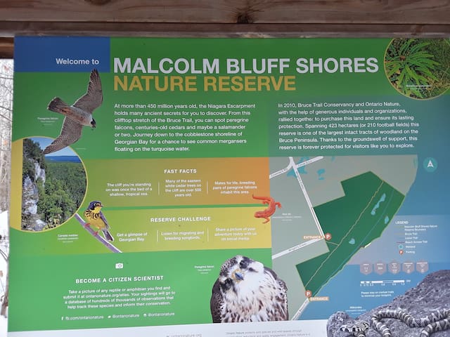
Malcolm Bluff Shores Nature Reserve
Wrights CrescentClose to the cottage, easy hike.
Malcolm Bluff Trail is a 6.8 kilometer moderately trafficked loop trail located near South Bruce Peninsula, Ontario, Canada that features beautiful wild flowers and is good for all skill levels. The trail is primarily used for hiking, walking, and nature trips.
Address: Wrights Crescent, South Bruce Peninsula, ON N0H 2T0
Look closely and you’ll discover that 400 million years ago, this land was submerged under a tropical sea. Look closer still, and you’ll see layers of embossed, fossilized coral shielding dolomite and limestone … rocks that erosion has carved out with hidden caves and overhanging cliffs.
It’s here that you’ll find geological finds such as the Grotto, a cave scooped out of the cliffs by the waves of ages and Overhanging Point, a massive bowl-shape that has been hollowed out of a cliff and is part of a favourite hike starting at the Cyprus Lake Trailhead.
Choose the loop that also takes you to the Grotto and Indian Head Cove. The woods portion of the hike is quite easy, but once the trail takes you to the rocky shore, you’ll understand why sturdy hiking boots with grippy soles are needed. Even in good weather, it can be slippery to navigate. Once you arrive at Overhanging Point you’ll see why people rave about the breathtaking view.
TIP: There’s an easy-to-miss hidden rabbit hole that can take you down to the Overhanging Point amphitheatre below.
Moving on to the Grotto, if you pick your way down to the shore, you can see the underwater cave on sunny days. If beaches are your thing, there are some spectacular sites to be found between the Grotto and the Halfway Log Dump Side Trail.
Fantastically eroded rocky spires and partially submerged slabs of rock greet you. As you continue on to Indian Head Cove, another tourist favorite, you’ll find the breathtaking lookout features the cliff plunging straight down into the waters below.
Address: Bruce Trail, Northern Bruce Peninsula, ON N0H 2R0
6 personas locales recomiendan
Overhanging Point
Bruce TrailLook closely and you’ll discover that 400 million years ago, this land was submerged under a tropical sea. Look closer still, and you’ll see layers of embossed, fossilized coral shielding dolomite and limestone … rocks that erosion has carved out with hidden caves and overhanging cliffs.
It’s here that you’ll find geological finds such as the Grotto, a cave scooped out of the cliffs by the waves of ages and Overhanging Point, a massive bowl-shape that has been hollowed out of a cliff and is part of a favourite hike starting at the Cyprus Lake Trailhead.
Choose the loop that also takes you to the Grotto and Indian Head Cove. The woods portion of the hike is quite easy, but once the trail takes you to the rocky shore, you’ll understand why sturdy hiking boots with grippy soles are needed. Even in good weather, it can be slippery to navigate. Once you arrive at Overhanging Point you’ll see why people rave about the breathtaking view.
TIP: There’s an easy-to-miss hidden rabbit hole that can take you down to the Overhanging Point amphitheatre below.
Moving on to the Grotto, if you pick your way down to the shore, you can see the underwater cave on sunny days. If beaches are your thing, there are some spectacular sites to be found between the Grotto and the Halfway Log Dump Side Trail.
Fantastically eroded rocky spires and partially submerged slabs of rock greet you. As you continue on to Indian Head Cove, another tourist favorite, you’ll find the breathtaking lookout features the cliff plunging straight down into the waters below.
Address: Bruce Trail, Northern Bruce Peninsula, ON N0H 2R0
About - “A garden of wildflowers” – this phrase recurs again and again in descriptions of the 33-hectare Petrel Point Nature Reserve. The wonderful sprinklings of pink, mauve, red, blue and yellow that fill the wetland through the seasons can only inspire a passion for nature.The reserve is a spectacular example of Great Lakes Coastal Meadow Marsh, a globally rare habitat. Slight changes in elevation in the wetland separate distinct communities of plants, many of them rare.
Plants and Animals - Petrel Point Nature Reserve is home to many unusual wildflowers due to its basic (high pH) groundwater. A dense white cedar swamp surrounds the reserve’s meadow marshes. The meadow marshes support a diverse community of carnivorous plants, including horned bladderworts, sundews and pitcher plants. Orchid lovers will find showy lady’s-slippers, rose pogonia, grass-pink, small purple-fringed orchids and broad-leaved twayblade scattered throughout the reserve.
Visiting - Due to the delicacy of the plant life at Petrel Point, visitors must explore from the walkways provided. The boardwalk is currently undergoing repairs in some sections to improve safety and accessibility for outdoor recreation experiences and better protect its sensitive ecological features. There are a number of other interesting areas nearby, including the Oliphant Fen, Reid Point Conservation Area, Walker Woods Conservation Area and Sauble Falls Provincial Park. Ontario Nature helped raise funds to purchase the Reid Point and Walker Woods properties.
Directions
From Highway 6 turn west at the town of Mar on Red Bay Road. Drive along Red Bay Road to its end at Huron road. Drive north on Huron Road roughly three kilometers, then turn left (west) on Petrel Point Road. Petrel Point Road divides the northern and southern halves of the reserve. Please park only on the north side of the road.
Address: Petrel Point Rd, South Bruce Peninsula, ON N0H 1X0
Petrel Point Nature Reserve
Petrel Point RoadAbout - “A garden of wildflowers” – this phrase recurs again and again in descriptions of the 33-hectare Petrel Point Nature Reserve. The wonderful sprinklings of pink, mauve, red, blue and yellow that fill the wetland through the seasons can only inspire a passion for nature.The reserve is a spectacular example of Great Lakes Coastal Meadow Marsh, a globally rare habitat. Slight changes in elevation in the wetland separate distinct communities of plants, many of them rare.
Plants and Animals - Petrel Point Nature Reserve is home to many unusual wildflowers due to its basic (high pH) groundwater. A dense white cedar swamp surrounds the reserve’s meadow marshes. The meadow marshes support a diverse community of carnivorous plants, including horned bladderworts, sundews and pitcher plants. Orchid lovers will find showy lady’s-slippers, rose pogonia, grass-pink, small purple-fringed orchids and broad-leaved twayblade scattered throughout the reserve.
Visiting - Due to the delicacy of the plant life at Petrel Point, visitors must explore from the walkways provided. The boardwalk is currently undergoing repairs in some sections to improve safety and accessibility for outdoor recreation experiences and better protect its sensitive ecological features. There are a number of other interesting areas nearby, including the Oliphant Fen, Reid Point Conservation Area, Walker Woods Conservation Area and Sauble Falls Provincial Park. Ontario Nature helped raise funds to purchase the Reid Point and Walker Woods properties.
Directions
From Highway 6 turn west at the town of Mar on Red Bay Road. Drive along Red Bay Road to its end at Huron road. Drive north on Huron Road roughly three kilometers, then turn left (west) on Petrel Point Road. Petrel Point Road divides the northern and southern halves of the reserve. Please park only on the north side of the road.
Address: Petrel Point Rd, South Bruce Peninsula, ON N0H 1X0
Nice hike during Summer & Fall
The trails are cut through rolling land, sheltered by hardwood and evergreen stands.
11 kilometers of cross-country ski trails, groomed for both classic and skate skiing 5 kilometers of snowshoe trails.
Address: 719533 ON-6, Wiarton, ON N0H 2T0
11 personas locales recomiendan
Sawmill Ski Trail
719533 ON-6Nice hike during Summer & Fall
The trails are cut through rolling land, sheltered by hardwood and evergreen stands.
11 kilometers of cross-country ski trails, groomed for both classic and skate skiing 5 kilometers of snowshoe trails.
Address: 719533 ON-6, Wiarton, ON N0H 2T0
For a spectacular view of ruralscapes and Georgian Bay this is the spot to bring your camera. Located northeast of Wiarton, 455.3 hectares atop the Niagara Escarpment, accessible from Grey County Road 1 via Zion Church Road in Oxenden. Then take Concession 24 (east) past Lake Charles, then left (north) on Centre Road and then right (east) onto Colpoy's Range Road. Parking is available along the roadside before the road descends a steep hill. Look for Bruce Trail blazes. The views are amazing from the east and north sides of the escarpment as you overlook the forests below and islands of Colpoy's Bay in the distance. Caution is advised as you near the sheer drop-offs. Keep dogs leashed. It is a 15 minute walk from the parking area and be aware of rocky terrain, tree roots, etc. Parking is not accessible during the winter and early spring.
Skinners Bluff Management Area
For a spectacular view of ruralscapes and Georgian Bay this is the spot to bring your camera. Located northeast of Wiarton, 455.3 hectares atop the Niagara Escarpment, accessible from Grey County Road 1 via Zion Church Road in Oxenden. Then take Concession 24 (east) past Lake Charles, then left (north) on Centre Road and then right (east) onto Colpoy's Range Road. Parking is available along the roadside before the road descends a steep hill. Look for Bruce Trail blazes. The views are amazing from the east and north sides of the escarpment as you overlook the forests below and islands of Colpoy's Bay in the distance. Caution is advised as you near the sheer drop-offs. Keep dogs leashed. It is a 15 minute walk from the parking area and be aware of rocky terrain, tree roots, etc. Parking is not accessible during the winter and early spring.
Close by, easy trail..
Spirit Rock Conservation Area draws people from afar for its local history, legends and remarkable view of Colpoy's Bay. Encompassing 87 hectares, the site features the historical "Corran" the home of Alexander McNeill, a Federal member of Parliament from 1881-1901. The Corran was a 17 room mansion lavished with oriental carvings, ancient weapons, tapestries and book-lined walls. As known as the McNeill Estate, there are many things to see: an impressive view from the top of the Niagara Escarpment, a spiral staircase to the water's edge, and access to the Bruce Trail.
Address Highway 6, Wiarton, Ontario
Telephone519-376-3076
Website www.greysauble.on.ca/conservation-areas
Latitude44.76218
Longitude-81.14178
50 personas locales recomiendan
Spirit Rock Conservation Area
92 Highway 6Close by, easy trail..
Spirit Rock Conservation Area draws people from afar for its local history, legends and remarkable view of Colpoy's Bay. Encompassing 87 hectares, the site features the historical "Corran" the home of Alexander McNeill, a Federal member of Parliament from 1881-1901. The Corran was a 17 room mansion lavished with oriental carvings, ancient weapons, tapestries and book-lined walls. As known as the McNeill Estate, there are many things to see: an impressive view from the top of the Niagara Escarpment, a spiral staircase to the water's edge, and access to the Bruce Trail.
Address Highway 6, Wiarton, Ontario
Telephone519-376-3076
Website www.greysauble.on.ca/conservation-areas
Latitude44.76218
Longitude-81.14178
The rugged shoreline rises some 50 metres above the crashing waves, exposing various gradations of the Silurian-age dolomite, roughly 400 to 425 million years old. Sea caves and other unusual rock formations have been carved by ancient waters. Karrens, which are small furrows in the limestone bedrock, demonstrate the erosive properties of rainwater. Dry upland forests predominate.
Address: 8 Carter Rd, Lion's Head, ON N0H 1W0
7 personas locales recomiendan
Smokey Head - White Bluff Provincial Park
8 Carter RdThe rugged shoreline rises some 50 metres above the crashing waves, exposing various gradations of the Silurian-age dolomite, roughly 400 to 425 million years old. Sea caves and other unusual rock formations have been carved by ancient waters. Karrens, which are small furrows in the limestone bedrock, demonstrate the erosive properties of rainwater. Dry upland forests predominate.
Address: 8 Carter Rd, Lion's Head, ON N0H 1W0
The rugged shoreline rises some 50 meters above the crashing waves, exposing various gradations of the Silurian-age dolomite, roughly 400 to 425 million years old. Sea caves and other unusual rock formations have been carved by ancient waters. Karrens, which are small furrows in the limestone bedrock, demonstrate the erosive properties of rainwater. Dry upland forests predominate.
Address: 8 Carter Rd, Lion's Head, ON N0H 1W0
White Bluff
54 Bruce TrailThe rugged shoreline rises some 50 meters above the crashing waves, exposing various gradations of the Silurian-age dolomite, roughly 400 to 425 million years old. Sea caves and other unusual rock formations have been carved by ancient waters. Karrens, which are small furrows in the limestone bedrock, demonstrate the erosive properties of rainwater. Dry upland forests predominate.
Address: 8 Carter Rd, Lion's Head, ON N0H 1W0
Beaches/Water Access 🏊♂️ ⛱
Enjoy an evening stroll on the beach to watch a glorious sunset.
Sauble Beach was recently named one of the 'Top 10 Beaches in the World' by the Toronto Star. With seven kilometers of pristine sandy beach, Sauble Beach is the second longest freshwater beach in the world! With that much beach, there's lots of room to bring the family and spread out! Swim, surf, kiteboard, SUP, jet ski, build castles, play volleyball or visit the famous Piping Plovers.
When you get hungry, there are many great eating spots in walking distance and lots of shops to pop in along the way.
Whatever you do, be sure to finish your day with a calm walk along the beach at dusk with some of the best sunsets you'll see anywhere!
Location:
1 Shore Road South, Sauble Beach, Ontario, N0H2G0
1-519-534-1400 or 1-877-534-1400
251 personas locales recomiendan
Sauble Beach
609 Lakeshore Blvd NEnjoy an evening stroll on the beach to watch a glorious sunset.
Sauble Beach was recently named one of the 'Top 10 Beaches in the World' by the Toronto Star. With seven kilometers of pristine sandy beach, Sauble Beach is the second longest freshwater beach in the world! With that much beach, there's lots of room to bring the family and spread out! Swim, surf, kiteboard, SUP, jet ski, build castles, play volleyball or visit the famous Piping Plovers.
When you get hungry, there are many great eating spots in walking distance and lots of shops to pop in along the way.
Whatever you do, be sure to finish your day with a calm walk along the beach at dusk with some of the best sunsets you'll see anywhere!
Location:
1 Shore Road South, Sauble Beach, Ontario, N0H2G0
1-519-534-1400 or 1-877-534-1400
Nice & quiet with lake access
Address: 39 Berford Park Rd #89, Wiarton, ON N0H 2T0
Hours: Open 24 hours
Phone: (519) 534-1400
Berford Lake Park
39 Berford Park RoadNice & quiet with lake access
Address: 39 Berford Park Rd #89, Wiarton, ON N0H 2T0
Hours: Open 24 hours
Phone: (519) 534-1400
This tract of shore land along Lake Huron, part of which is dominated by a beaver swamp, has a good beach for swimming. Park Facilities and Activities A parking lot and toilets are the only visitor facilities. Swimming and beach use are the main activities.
Address: 81 Old Womans River Rd, Lion's Head, ON N0H 1W0
40 personas locales recomiendan
Black Creek Provincial Park
81 Old Womans River RdThis tract of shore land along Lake Huron, part of which is dominated by a beaver swamp, has a good beach for swimming. Park Facilities and Activities A parking lot and toilets are the only visitor facilities. Swimming and beach use are the main activities.
Address: 81 Old Womans River Rd, Lion's Head, ON N0H 1W0
Sightseeing 👓
The Saugeen River is located in southern Ontario, Canada. The river begins in the Osprey Wetland Conservation Lands and flows generally north-west about 160 kilometres before exiting into Lake Huron. The river is navigable for some distance, and was once an important barge route.
7 personas locales recomiendan
Saugeen River
The Saugeen River is located in southern Ontario, Canada. The river begins in the Osprey Wetland Conservation Lands and flows generally north-west about 160 kilometres before exiting into Lake Huron. The river is navigable for some distance, and was once an important barge route.
Bruce's Caves Conservation Area derives its greatest significance from the unique cave formations found along the escarpment face. These caves were formed by the wave action of post-glacial Lake Algonquin, 7,000 to 8,000 years ago. Bruce's Caves Conservation area consists of: 7 hectares of Niagara Escarpment and rock talus, upland hardwoods, wooded swamp, caves and access to the Bruce Trail.
Address: Grey Rd 1, Wiarton, ON N0H 2T0
64 personas locales recomiendan
Bruce's Caves Conservation Area
Grey Road 1Bruce's Caves Conservation Area derives its greatest significance from the unique cave formations found along the escarpment face. These caves were formed by the wave action of post-glacial Lake Algonquin, 7,000 to 8,000 years ago. Bruce's Caves Conservation area consists of: 7 hectares of Niagara Escarpment and rock talus, upland hardwoods, wooded swamp, caves and access to the Bruce Trail.
Address: Grey Rd 1, Wiarton, ON N0H 2T0
Reputed great fishing. Check fishing regulations before heading out.
Address: Dennys Dam Rd, Southampton, ON N0H 2L0
Phone: (519) 756-7781 ext. 227
Denny's Dam Conservation Area
Dennys Dam RoadReputed great fishing. Check fishing regulations before heading out.
Address: Dennys Dam Rd, Southampton, ON N0H 2L0
Phone: (519) 756-7781 ext. 227
Great Park in the middle of Owen Sound.
A river runs through this public park also offering sports facilities such as a pool & mini golf.
Address: 75 2nd Ave E, Owen Sound, ON N4K 5T2
Phone: (519) 376-1440
58 personas locales recomiendan
Harrison Park
75 2nd Ave EGreat Park in the middle of Owen Sound.
A river runs through this public park also offering sports facilities such as a pool & mini golf.
Address: 75 2nd Ave E, Owen Sound, ON N4K 5T2
Phone: (519) 376-1440
Kincardine Scottish Pipe Band Parade
Share this story...As eight o'clock approaches ...As eight o'clock approaches ...
... there’s an energy that starts to build as the locals know what to expect.
First, you'll hear the faint drone of the bagpipes as the band begins to warm up in Victoria Park. Faithful attendees will be setting up their lawn chairs to claim their spot along the parade route and the excitable laughter of those who are standing in line for ice cream while the anticipation grows. You’ll see the lawn chairs fill and the sidewalks filled before the clock strikes 8:00pm – the clock doesn’t chime, but you’ll know by the first skirl of the bagpipes.
A main street tradition in Kincardine since 1948, you’ll delight in the sights and sounds of Scotland as the Kincardine Scottish Pipe Band parades Queen Street.
Thousands of Spectators Line UpThousands of Spectators Line Up
Don’t be afraid to become part of the parade! The band forms up at Victoria Park (Durham Market Square North) and proceeds down Queen Street with hundreds, if not thousands of spectators, falling in line directly behind.
At 8pm sharp, rain or shine (and we really mean rain or shine), we march!
Follow the Band as they parade north on Queen Street to Quinn Plaza (just south of Broadway Street), where the Band will take a short, and well-deserved break, before embarking on the return route. Be sure to stay with the Band all the way back to Victoria Park to enjoy a short concert following.
Are you a piper or a drummer?Are you a piper or a drummer?
You're welcome to join in!
All pipers and drummers are welcome to march and play with the band - the only rule is proper dress is required. The Kincardine Pipe Band has played host to musicians from all over the world and would love to include you.
Haunting Sounds of the Phantom PiperHaunting Sounds of the Phantom Piper
The band doesn’t just make an appearance on Saturday nights – be sure to claim one of Kincardine’s blue beach chairs, a spot near the harbour or a table at the Bruce Steakhouse before the sun starts setting. You’re in for a treat!
As the sun starts to set, the Phantom Piper starts up to pipe the sun to sleep from atop the Kincardine Lighthouse. The lament of the pipes can be heard as the sun starts its descent, until well below the horizon. This unique experience is an ode to the Legend of Donald Sinclair, which can be found inscribed on a plaque at Walker’s Lookout.
Address: 310 Durham Market St N, Kincardine, ON N2Z 1Z9
6 personas locales recomiendan
Kincardine Scottish Festival & Highland Games
310 Durham Market St NKincardine Scottish Pipe Band Parade
Share this story...As eight o'clock approaches ...As eight o'clock approaches ...
... there’s an energy that starts to build as the locals know what to expect.
First, you'll hear the faint drone of the bagpipes as the band begins to warm up in Victoria Park. Faithful attendees will be setting up their lawn chairs to claim their spot along the parade route and the excitable laughter of those who are standing in line for ice cream while the anticipation grows. You’ll see the lawn chairs fill and the sidewalks filled before the clock strikes 8:00pm – the clock doesn’t chime, but you’ll know by the first skirl of the bagpipes.
A main street tradition in Kincardine since 1948, you’ll delight in the sights and sounds of Scotland as the Kincardine Scottish Pipe Band parades Queen Street.
Kincardine Scottish Pipe Band Parade
Share this story...As eight o'clock approaches ...As eight o'clock approaches ...
... there’s an energy that starts to build as the locals know what to expect.
First, you'll hear the faint drone of the bagpipes as the band begins to warm up in Victoria Park. Faithful attendees will be setting up their lawn chairs to claim their spot along the parade route and the excitable laughter of those who are standing in line for ice cream while the anticipation grows. You’ll see the lawn chairs fill and the sidewalks filled before the clock strikes 8:00pm – the clock doesn’t chime, but you’ll know by the first skirl of the bagpipes.
A main street tradition in Kincardine since 1948, you’ll delight in the sights and sounds of Scotland as the Kincardine Scottish Pipe Band parades Queen Street.
Thousands of Spectators Line UpThousands of Spectators Line Up
Don’t be afraid to become part of the parade! The band forms up at Victoria Park (Durham Market Square North) and proceeds down Queen Street with hundreds, if not thousands of spectators, falling in line directly behind.
At 8pm sharp, rain or shine (and we really mean rain or shine), we march!
Follow the Band as they parade north on Queen Street to Quinn Plaza (just south of Broadway Street), where the Band will take a short, and well-deserved break, before embarking on the return route. Be sure to stay with the Band all the way back to Victoria Park to enjoy a short concert following.
Are you a piper or a drummer?Are you a piper or a drummer?
You're welcome to join in!
All pipers and drummers are welcome to march and play with the band - the only rule is proper dress is required. The Kincardine Pipe Band has played host to musicians from all over the world and would love to include you.
Haunting Sounds of the Phantom PiperHaunting Sounds of the Phantom Piper
The band doesn’t just make an appearance on Saturday nights – be sure to claim one of Kincardine’s blue beach chairs, a spot near the harbour or a table at the Bruce Steakhouse before the sun starts setting. You’re in for a treat!
As the sun starts to set, the Phantom Piper starts up to pipe the sun to sleep from atop the Kincardine Lighthouse. The lament of the pipes can be heard as the sun starts its descent, until well below the horizon. This unique experience is an ode to the Legend of Donald Sinclair, which can be found inscribed on a plaque at Walker’s Lookout.
Address: 310 Durham Market St N, Kincardine, ON N2Z 1Z9
Great for birding.
MacGregor Point Provincial Park is a park located on Lake Huron, off of Bruce Road 33 near Port Elgin, Ontario, Canada. The varied habitat found within the park includes a seven-kilometre stretch of coast, coastal wetlands, forests, and dunes.
Address: 1593 Bruce County Rd 33, Port Elgin, ON N0H 2C5
Area: 12.04 km²
Hours: Open ⋅ Closes 7 p.m.
47 personas locales recomiendan
Parque Provincial Macgregor Point
1593 Bruce Rd 33Great for birding.
MacGregor Point Provincial Park is a park located on Lake Huron, off of Bruce Road 33 near Port Elgin, Ontario, Canada. The varied habitat found within the park includes a seven-kilometre stretch of coast, coastal wetlands, forests, and dunes.
Address: 1593 Bruce County Rd 33, Port Elgin, ON N0H 2C5
Area: 12.04 km²
Hours: Open ⋅ Closes 7 p.m.
Historical landmark in Owen Sound, Ontario
Address: 601 2nd Ave W, Owen Sound, ON N4K 4M2
Phone: (519) 371-9833
Mill Dam
601 2nd Ave WHistorical landmark in Owen Sound, Ontario
Address: 601 2nd Ave W, Owen Sound, ON N4K 4M2
Phone: (519) 371-9833
Built by the McCallum family in 1920, Morland Place was originally a small, country cottage-style home. The expansion at the rear was modelled after the 1870s regency Georgian villa style. The gardens, started in 1960, were influenced by European architectural style. Containing concrete statues and benches, the Tree Park and Perennial Garden and Maze are not to be missed.
ARCHITECTURE
Year built: 1920
Architectural style: Georgian
Building type: Private residence
Landscape: Garden, Park
102645 Grey Road 18
Georgian Bluffs, Ontario
Telephone: 519-376-4617
www.visitgrey.ca/business/morland-place
Morland Place
102613-102655 Grey County Rd 18Built by the McCallum family in 1920, Morland Place was originally a small, country cottage-style home. The expansion at the rear was modelled after the 1870s regency Georgian villa style. The gardens, started in 1960, were influenced by European architectural style. Containing concrete statues and benches, the Tree Park and Perennial Garden and Maze are not to be missed.
ARCHITECTURE
Year built: 1920
Architectural style: Georgian
Building type: Private residence
Landscape: Garden, Park
102645 Grey Road 18
Georgian Bluffs, Ontario
Telephone: 519-376-4617
www.visitgrey.ca/business/morland-place
Great place to visit.
http://www.ruralrootz.com/
15 personas locales recomiendan
Rural Rootz Nature Reserve
645 Northacres RdGreat place to visit.
http://www.ruralrootz.com/
Easy hike, great sandy beach,. Follow the boardwalk in late spring/early summer to discover some of the Bruce's wild orchids.
Address: Dorcas Bay Road, North Bruce Peninsula
Description: Singing Sands Beach is located off of Dorcas Bay Road near Tobermory. This large sand beach with shallow waters is part of Bruce Peninsula National Park. Please visit the Parks Canada website for further information.
93 personas locales recomiendan
Singing Sands
Dorcas Bay RoadEasy hike, great sandy beach,. Follow the boardwalk in late spring/early summer to discover some of the Bruce's wild orchids.
Address: Dorcas Bay Road, North Bruce Peninsula
Description: Singing Sands Beach is located off of Dorcas Bay Road near Tobermory. This large sand beach with shallow waters is part of Bruce Peninsula National Park. Please visit the Parks Canada website for further information.
Home of one of Canada's spring forecasters. Wiarton Willie Festival happens in February.
15 personas locales recomiendan
Wiarton Willie Statue
Home of one of Canada's spring forecasters. Wiarton Willie Festival happens in February.
Following the ceding of the Bruce Peninsula to the Province of Canada in 1854 by the Ojibway, the entire Peninsula, including the rocky forest land back of Cabot Head, was divided into one hundred acre farm lots.
Not until 1870 was the upper Peninsula (Lindsay and St. Edmunds townships) thrown open to settlement and timbering.
On May 4, 1870, a cutting license was granted to Cook & Brothers, of Toronto, to a large tract of forest which included the highlands of Cabot Head. On July 15, 1871, George J. Cook purchased a lot which took in most of the western shore of Wingfield Basin.
For more than a decade Cook & Brothers, later known as the British Canadian Lumbering & Timber Company, held exclusive rights to the forests of Lindsay and St. Edmunds townships. Finally, in 1882, with most of the large pine gone and the Company’s political influence waning, the last of their licenses was revoked and their former holdings thrown open to other, smaller entrepreneurs.
Wingfield Basin
Following the ceding of the Bruce Peninsula to the Province of Canada in 1854 by the Ojibway, the entire Peninsula, including the rocky forest land back of Cabot Head, was divided into one hundred acre farm lots.
Not until 1870 was the upper Peninsula (Lindsay and St. Edmunds townships) thrown open to settlement and timbering.
On May 4, 1870, a cutting license was granted to Cook & Brothers, of Toronto, to a large tract of forest which included the highlands of Cabot Head. On July 15, 1871, George J. Cook purchased a lot which took in most of the western shore of Wingfield Basin.
For more than a decade Cook & Brothers, later known as the British Canadian Lumbering & Timber Company, held exclusive rights to the forests of Lindsay and St. Edmunds townships. Finally, in 1882, with most of the large pine gone and the Company’s political influence waning, the last of their licenses was revoked and their former holdings thrown open to other, smaller entrepreneurs.
Waterfalls 🏞
Best to visit in Spring & early Summer
This plunge waterfall sits approximately 30 metres tall and is quite an impressive sight to see… in the cooler months. It’s not uncommon for Eugenia Falls to be a trickle in the summer so I highly recommend a winter or spring visit. Enjoy the views of the crest from behind the stone wall before following the trail south.
Address: County Road 13, Eugenia, Ontario
Telephone: 519-376-3076
40 personas locales recomiendan
Eugenia Falls Conservation Area
County Road 13This plunge waterfall sits approximately 30 metres tall and is quite an impressive sight to see… in the cooler months. It’s not uncommon for Eugenia Falls to be a trickle in the summer so I highly recommend a winter or spring visit. Enjoy the views of the crest from behind the stone wall before following the trail south.
Address: County Road 13, Eugenia, Ontario
Telephone: 519-376-3076
Say hello to Hogg’s Falls! This plunge waterfall sits just over 7 metres tall and is surrounded by lush wilderness. Named after William Hogg, it was once home to a sawmill which he built in the 1870s. However you won’t find anything man-made here since the mill burnt down in the late 1880s – except the rope you can use to scale down the escarpment!
Hogg’s Falls is definitely a waterfall worth visiting in every season. While her flow will be less in the summer months, the bright green vegetation is beautiful. Autumn brings with it the beautiful golds and reds which will just add to the magic. However, winter is hands down my favourite as the icicles are just breathtaking. It also makes climbing down to her base a little easier since the ground should be frozen and not as mucky. Though you may need to dig in the snow a little to find the rope!
The parking area off of Lower Valley Road isn’t overly big, however I’ve never run into any trouble. You’ll want to follow the Bruce Trail east along the Boyne River (the water will be to your left). It shouldn’t take you more than 15 minutes to reach Hogg’s Falls along the main trail. If you don’t hear the falls by 10 minutes in then chances are you’ve gone the wrong way! Looking for a longer hike? You can continue along the Bruce Trail and it’ll take you right to your next waterfall destination… though it’s quite the trek at 14km return.
60 personas locales recomiendan
Hoggs Falls
Say hello to Hogg’s Falls! This plunge waterfall sits just over 7 metres tall and is surrounded by lush wilderness. Named after William Hogg, it was once home to a sawmill which he built in the 1870s. However you won’t find anything man-made here since the mill burnt down in the late 1880s – except the rope you can use to scale down the escarpment!
Hogg’s Falls is definitely a waterfall worth visiting in every season. While her flow will be less in the summer months, the bright green vegetation is beautiful. Autumn brings with it the beautiful golds and reds which will just add to the magic. However, winter is hands down my favourite as the icicles are just breathtaking. It also makes climbing down to her base a little easier since the ground should be frozen and not as mucky. Though you may need to dig in the snow a little to find the rope!
The parking area off of Lower Valley Road isn’t overly big, however I’ve never run into any trouble. You’ll want to follow the Bruce Trail east along the Boyne River (the water will be to your left). It shouldn’t take you more than 15 minutes to reach Hogg’s Falls along the main trail. If you don’t hear the falls by 10 minutes in then chances are you’ve gone the wrong way! Looking for a longer hike? You can continue along the Bruce Trail and it’ll take you right to your next waterfall destination… though it’s quite the trek at 14km return.
The southernmost of all of the Grey County waterfalls, the Holstein Dam is located within the town it’s named after. This waterfall might be more manmade than natural but it’s still a fan favourite. Sitting at just 5 metres tall, the cascade waterfall isn’t the biggest but she’s a wide one! Watch as the water from the Mill Pond flows down Norman Reeves Creek across the dam. Head just a little downstream from the Jubilee Park entrance for the best view of the falls. You can also enjoy the falls from a different angle by hiking to the old railway bridge that runs across the top of the dam. Jubilee Park also offers a picnic area, baseball diamond, pavilion as well as some playground equipment. The Holstein Dam is one of the smallest of Grey County’s waterfalls, meaning you’re just getting a small taste of what the area has to offer!
To get to the Holstein Dam, you’ll want to take a slight detour from Highway 6 towards the town of Holstein. Hop onto County Road 109 and head towards the Holstein General Store. When you see Lane Street, turn onto it where you’ll find the entrance to Jubilee Park.
Holstein Dam
The southernmost of all of the Grey County waterfalls, the Holstein Dam is located within the town it’s named after. This waterfall might be more manmade than natural but it’s still a fan favourite. Sitting at just 5 metres tall, the cascade waterfall isn’t the biggest but she’s a wide one! Watch as the water from the Mill Pond flows down Norman Reeves Creek across the dam. Head just a little downstream from the Jubilee Park entrance for the best view of the falls. You can also enjoy the falls from a different angle by hiking to the old railway bridge that runs across the top of the dam. Jubilee Park also offers a picnic area, baseball diamond, pavilion as well as some playground equipment. The Holstein Dam is one of the smallest of Grey County’s waterfalls, meaning you’re just getting a small taste of what the area has to offer!
To get to the Holstein Dam, you’ll want to take a slight detour from Highway 6 towards the town of Holstein. Hop onto County Road 109 and head towards the Holstein General Store. When you see Lane Street, turn onto it where you’ll find the entrance to Jubilee Park.
Best in the spring, just after snow melts.
One of three waterfalls that surround the city of Owen Sound, Ontario, Canada, Inglis Falls is the largest and most impressive. It is also the most visited.
Probably the most visited of Grey County’s waterfalls, you’ll immediately understand why once you lay your eyes upon Inglis Falls. This cascade waterfall sits approximately 17 metres tall as the Sydenham River tumbles over the numerous layers of the Niagara Escarpment. The entire area surrounding the falls is gorgeous and worth exploring. Interpretive signage tells about the history of the grist mill that one stood at the top of the falls. Rumour has it you can get to the base of the falls by following the Bruce Trail down towards the riverbed. I’ve never done it myself as I’m happy to enjoy the incredible views available from the trail.
For me, Inglis Falls is a little different as it will always have a special place in my heart. It brings me a sense of comfort that very few waterfalls do. Don’t get me wrong, I love each and every waterfall I visit. However, very few have the level of calm that I feel like I do when I’m at Inglis Falls. I’m reminded of my grandmother telling me stories of how her mother’s father’s brother ran the grist mill in the late 1800s. I still have yet to investigate this to see if it’s true, but if it is then I believe he would have been the gentleman to take over operations from Charles Woodhead in 1883.
Whether you find a spiritual connection to Inglis Falls or not, I wouldn’t be surprised to hear that she’s the most memorable stop on your Grey County waterfall road trip.
Address: 237785 Inglis Falls Rd, Owen Sound, ON N4K 5N6
Closes 7 p.m.
Phone: (519) 376-3076
109 personas locales recomiendan
Inglis Falls
237785 Inglis Falls RoadBest in the spring, just after snow melts.
One of three waterfalls that surround the city of Owen Sound, Ontario, Canada, Inglis Falls is the largest and most impressive. It is also the most visited.
Probably the most visited of Grey County’s waterfalls, you’ll immediately understand why once you lay your eyes upon Inglis Falls. This cascade waterfall sits approximately 17 metres tall as the Sydenham River tumbles over the numerous layers of the Niagara Escarpment. The entire area surrounding the falls is gorgeous and worth exploring. Interpretive signage tells about the history of the grist mill that one stood at the top of the falls. Rumour has it you can get to the base of the falls by following the Bruce Trail down towards the riverbed. I’ve never done it myself as I’m happy to enjoy the incredible views available from the trail.
For me, Inglis Falls is a little different as it will always have a special place in my heart. It brings me a sense of comfort that very few waterfalls do. Don’t get me wrong, I love each and every waterfall I visit. However, very few have the level of calm that I feel like I do when I’m at Inglis Falls. I’m reminded of my grandmother telling me stories of how her mother’s father’s brother ran the grist mill in the late 1800s. I still have yet to investigate this to see if it’s true, but if it is then I believe he would have been the gentleman to take over operations from Charles Woodhead in 1883.
Whether you find a spiritual connection to Inglis Falls or not, I wouldn’t be surprised to hear that she’s the most memorable stop on your Grey County waterfall road trip.
Address: 237785 Inglis Falls Rd, Owen Sound, ON N4K 5N6
Closes 7 p.m.
Phone: (519) 376-3076
Jones Falls is a pretty waterfall that is interesting to explore. It's a decent size, though smaller than the better known Inglis Falls and Indian Falls, both also in the outskirts of Owen Sound. You can park along the main east-west road leading west from Owen Sound, from which the falls is visible, at least when the leaves are off the trees. A short walk through the woods leads to a footbridge over the river above the falls, followed by more trails. I think that one of the trails goes to the bottom of the falls. This is in a conservation area, and makes for a nice short hike.
Follow the kilometre-long trail to Jones Falls where you’ll see the Pottawatomi River drop 12 metres down the Niagara Escarpment. This cascade waterfall truly is beautiful as you admire the numerous layers of bedrock the water tumbles over. For best views of the waterfall, I recommend crossing over the arch bridge to the south side of the falls. You won’t be surprised to see the Bruce Trail one again as it runs through the area. While Jones Falls is gorgeous in the springtime, it’s not uncommon to see little to no flow by the time late summer rolls around.
The old-growth forest here is gorgeous and it would be a sin not to take some time to explore it. It’s possible to get to the base of Jones Falls by following the trails downstream then heading against the water. As always, use caution when not on an official trail, especially because the rocks can be very slippery here!
Hwy 21 and Hwy 6, Owen Sound, Ontario N4K 5N7 Canada
1- 519-376-3076
31 personas locales recomiendan
Jones Falls
717875 ON-6Jones Falls is a pretty waterfall that is interesting to explore. It's a decent size, though smaller than the better known Inglis Falls and Indian Falls, both also in the outskirts of Owen Sound. You can park along the main east-west road leading west from Owen Sound, from which the falls is visible, at least when the leaves are off the trees. A short walk through the woods leads to a footbridge over the river above the falls, followed by more trails. I think that one of the trails goes to the bottom of the falls. This is in a conservation area, and makes for a nice short hike.
Follow the kilometre-long trail to Jones Falls where you’ll see the Pottawatomi River drop 12 metres down the Niagara Escarpment. This cascade waterfall truly is beautiful as you admire the numerous layers of bedrock the water tumbles over. For best views of the waterfall, I recommend crossing over the arch bridge to the south side of the falls. You won’t be surprised to see the Bruce Trail one again as it runs through the area. While Jones Falls is gorgeous in the springtime, it’s not uncommon to see little to no flow by the time late summer rolls around.
The old-growth forest here is gorgeous and it would be a sin not to take some time to explore it. It’s possible to get to the base of Jones Falls by following the trails downstream then heading against the water. As always, use caution when not on an official trail, especially because the rocks can be very slippery here!
Hwy 21 and Hwy 6, Owen Sound, Ontario N4K 5N7 Canada
1- 519-376-3076
Similar to the Holstein Dam, McGowan Falls is regulated by the dam above it as it controls the water flowing towards Lake Huron. Approximately 4 metres tall and 15 metres wide, this cascade waterfall is a hot spot for swimming in the summer months. Despite having a man-made influence, the area itself is beautiful with a wonderful side path on the opposite side of the river. There is even a little tunnel which you might be able to swim along if the water level is low like it is now!
Don’t forget to check out the town of Durham before you head out. There are a number of beautiful murals and one even depicts McGowan Falls! You’ll find a few places in town for a bite to eat as well as a cafe or two if you need a caffeine boost.
11 personas locales recomiendan
McGowan Falls
Similar to the Holstein Dam, McGowan Falls is regulated by the dam above it as it controls the water flowing towards Lake Huron. Approximately 4 metres tall and 15 metres wide, this cascade waterfall is a hot spot for swimming in the summer months. Despite having a man-made influence, the area itself is beautiful with a wonderful side path on the opposite side of the river. There is even a little tunnel which you might be able to swim along if the water level is low like it is now!
Don’t forget to check out the town of Durham before you head out. There are a number of beautiful murals and one even depicts McGowan Falls! You’ll find a few places in town for a bite to eat as well as a cafe or two if you need a caffeine boost.
Please note - Pre-paid parking reservations are required effective April 21, 2023. Further links will be posted when they become available. See here....
Park Advisories - Obtain your daily vehicle permit up to five days in advance to guarantee your day use spot at this park.
Visit the Ontario Parks day use page to learn more.
Just north of Sauble Beach, Sauble Falls is the end of the Sauble River as it flows to Lake Huron. Easy access. Awesome in the spring just after the winter snow melt.
Sauble Falls Provincial Park is located in the community of Sauble Falls, town of South Bruce Peninsula, Bruce County in southwestern Ontario, Canada. It is in the lower drainage basin of the Sauble River, which flows into Lake Huron.
1400 Sauble Falls Rd, Wiarton, ON N0H 2T0
31 personas locales recomiendan
Sauble Falls
Please note - Pre-paid parking reservations are required effective April 21, 2023. Further links will be posted when they become available. See here....
Park Advisories - Obtain your daily vehicle permit up to five days in advance to guarantee your day use spot at this park.
Visit the Ontario Parks day use page to learn more.
Just north of Sauble Beach, Sauble Falls is the end of the Sauble River as it flows to Lake Huron. Easy access. Awesome in the spring just after the winter snow melt.
Sauble Falls Provincial Park is located in the community of Sauble Falls, town of South Bruce Peninsula, Bruce County in southwestern Ontario, Canada. It is in the lower drainage basin of the Sauble River, which flows into Lake Huron.
1400 Sauble Falls Rd, Wiarton, ON N0H 2T0
This waterfall is on private property, however the owners of Walter’s Falls are kind enough to let visitors come in and admire it. On long weekends and in the summer months, you may need to park further out as the parking closest to the inn is reserved for guests. Please be respectful of this!
Head over to the viewing platform where you can watch Walter’s Creek plunge into the riverbed below. Both the creek and falls were named after John Walter and his family, pioneers who settled onto the traditional lands of the Anishinaabe and Odawa many years ago. Here the Walter established a grist mill which has since become The Falls Inn.
31 personas locales recomiendan
Walters Falls
This waterfall is on private property, however the owners of Walter’s Falls are kind enough to let visitors come in and admire it. On long weekends and in the summer months, you may need to park further out as the parking closest to the inn is reserved for guests. Please be respectful of this!
Head over to the viewing platform where you can watch Walter’s Creek plunge into the riverbed below. Both the creek and falls were named after John Walter and his family, pioneers who settled onto the traditional lands of the Anishinaabe and Odawa many years ago. Here the Walter established a grist mill which has since become The Falls Inn.
The nature reserve was created thanks to the generous donation of Mr James Horwood who has been a supporter of the Bruce Trail Conservancy for a long time. Named in memory of his parents, Webwood Falls and the area surrounding it is now permanently protected by the Bruce Trail Conservancy. It’s been quite a few years since I visited but there should be some parking along the road here. Try not to park right on the bend nor obstruct traffic as you enjoy this peaceful area.
Webwood Falls is one of the smaller Grey County waterfalls but its location adds to the magic. Two small streams meld to form the flow that converges as their water tumbles over the crest. While it is possible to get to the base of the falls (albeit it’s a slippery slope!), it’s better if you don’t. Webwood Falls is located within a very delicate eco-system and it’s already falling victim to significant erosion. Please admire her from the top of the falls so that this important habitat can stay intact for the bees, butterflies, deer and more who depend on it for survival.
7 personas locales recomiendan
Webwood Falls Nature Reserve
Sideroad 25The nature reserve was created thanks to the generous donation of Mr James Horwood who has been a supporter of the Bruce Trail Conservancy for a long time. Named in memory of his parents, Webwood Falls and the area surrounding it is now permanently protected by the Bruce Trail Conservancy. It’s been quite a few years since I visited but there should be some parking along the road here. Try not to park right on the bend nor obstruct traffic as you enjoy this peaceful area.
Webwood Falls is one of the smaller Grey County waterfalls but its location adds to the magic. Two small streams meld to form the flow that converges as their water tumbles over the crest. While it is possible to get to the base of the falls (albeit it’s a slippery slope!), it’s better if you don’t. Webwood Falls is located within a very delicate eco-system and it’s already falling victim to significant erosion. Please admire her from the top of the falls so that this important habitat can stay intact for the bees, butterflies, deer and more who depend on it for survival.
Lighthouses on the Bruce Peninsula
The Cape Croker Lighthouse is a lighthouse located on the south-east corner of Neyaashiinigmiing 27 native reserve in Ontario, Canada. It is a part of the Chippewas of Nawash Unceded First Nation. It was first built in 1898, but was replaced in 1902 with the current lighthouse.
Cape Croker Lighthouse
The Cape Croker Lighthouse is a lighthouse located on the south-east corner of Neyaashiinigmiing 27 native reserve in Ontario, Canada. It is a part of the Chippewas of Nawash Unceded First Nation. It was first built in 1898, but was replaced in 1902 with the current lighthouse.
Before there were any lighthouses on Georgian Bay, a few villages would place a light on a pole to help guide ships into their harbors. In 1855, the railroad reached Georgian Bay’s shores at Collingwood, making the area an important transshipment center and prompting the Imperial Government to construct a series of stone lighthouses to light Lake Huron from Point Clark to Christian Island.
The lighthouse on Cove Island, situated at Gig Point on the northwest tip of the island, marks the strait between Lake Huron and Georgian Bay and has the distinction of being the first lighthouse to be lit on Georgian Bay and the last to have its keeper removed. Construction, under the direction of contractor John Brown, began in the summer of 1855. The site was marked by the “squaring of a small tree,” and the crew of sixteen men, consisting of a foreman, four stone masons, three stone cutters, and eight laborers, began the painstaking task of building the tower with the assistance of a horse. The white limestone used to construct the tower was extracted from the island. Budgets ran over, construction was delayed at times, and by November 1855, only the dwelling and first storey of the tower were completed. A year later, in October 1856, the tower had reached its full height of eighty feet. The stonework was completed in 1857, but it wasn’t until 1858, when a crew of French technicians, under the direction of A. de St. Aubin, assembled the twelve-sided prefabricated lantern room and the second-order Fresnel lens mechanism, that the lighthouse went into service. Keeper George Collins lit the lamp inside the giant lens for the first time on October 30, 1858. In a letter dated November 2, 1858, engineer William Scott described the lighting apparatus then gave his thoughts and impressions while he watched the light illuminate the dark night sky for the first time:
This light is the Lenticular Flash light, revolving on its axis every 10 minutes, but producing the Flash or wave of light every 30 seconds or twice in one minute. The effect from a distance is Grand beyond description as it seems to gather together, rolling itself up into the dark cloudy night and then bursting out into a brilliant flame that illuminates the whole horizon, and cannot be better illustrated, than by the sudden appearance of a Brilliant sun breaking out of a dark rolling cloud. Keeper Collins, who came to Cove Island with his wife Sophia and four-year-old son Charles, received an annual salary of $435. They arrived on May 22, 1858, and Collins maintained a light on a pole, while the tower was being completed. He described some of the hardships he initially faced in the lighthouse: I beg to report that in consequence of the rain which has been coming in the tower since Mr. Scott left and for the want of a stove to keep it dry. All the inside parts of the lantern glass is a glitter of ice. I have been constant tending the machinery and the above. Myself and acting assistant is nearly frozen before our watch is over we have both of us very bad cold. Every thing wet & freezing around us I shall do all in my power to keep a good a light as possible… To make matters even worse Collins was “from and after the 22nd day of November A.D. 1858 and until the 12th day of April 1859 . . . deprived of the help of any assistant other than his wife Sophia Collins.” Keeper Collins was transferred to Nottawasaga Island on September 20, 1859, when he worked out a deal with David McBeath to swap assignments. It was early December 1860, when McBeath, living at the station with his wife, Mary Jane, and their five children, had not yet received the station’s regular provisions. After rationing their food for weeks, the family was becoming desperate. With the lake beginning to freeze, the McBeaths had a decision to make: they could either stay on the island and hope that food arrived soon or flee the lighthouse and risk reaching the mainland in the station’s boat. A month earlier, McBeath had sent an urgent letter to the Department of Public Works and twice had sailed into the shipping lane to flag down a passing vessel – all seemingly to no avail. Keeper McBeath’s plea for help had been passed through several ships, but there was only one steamer capable of cutting through the icy waters, the Rescue, which was on her last trip of the season but expected back at her winter quarters at Collingwood any day. When the Rescue arrived in port, James Dick, its captain, agreed to attempt a trip to Cove Island. In the middle of a raging storm, Captain Dick departed Collingwood harbour on the afternoon of December 6 and safely delivered McBeath’s provisions. Dick reported that the lightkeeper and his family were “about to commit themselves to the Lake upon a very insecure Raft, in the midst of the Storm.” The appropriately named Rescue battled the heavy seas back to Collingwood and was stowed for the winter. David McBeath died on March 5, 1872, and William McBeath took over as keeper. A steam fog alarm was added to the station in 1885, and it was upgraded to a diaphone foghorn in 1905. The current foghorn building was built in 1947 to replace the original that was destroyed by fire, and it contains the last intact diaphone apparatus on the Great Lakes. Iris was nineteen years old in 1945, when she married Keeper Harold “Hal” Banas and traded mainland life to be one of Cove Island’s three inhabitants, the other being assistant keeper Earl Banas, Hal’s brother. The couple’s wedding ceremony was held on the island, with Earl as best man. He said, “Hal and Iris pulled a surprise on me. I didn’t know a thing about it until I met the minister and he said his visit was to officiate at the marriage.” The following April, Hugh Rumley, Flowerpot Island’s lightkeeper, noticed that Cove Island light had remained dark throughout the night. At daybreak, Rumley sped across the rough seas and was greeted by Iris, who reported that her husband and his assistant had not returned the previous night after going out to test their new twenty-foot boat and motor. Iris’ only way of signaling for help was to keep the light dark. A sea and air search began, and later that day, an aircrew spotted the station’s partially submerged boat near Half Moon Island. Moments later, the two marooned keepers were seen waving from the island. The boat’s new engine had broken down, and while rowing back to Cove Island, the oarlocks snapped, leaving the two keepers to the whims of the sea. William Spears, lightkeeper at Cove Island from 1949 to 1976, spent his life on the lights. He was six months old, when his father William, became keeper of Flowerpot Island. His duties at Cove Island included reporting weather and other information to the Coast Guard three times a day. During the reports, he would mention any sign of trouble such as bonfires on the tiny islands in the vicinity that might be distress signals. Weather permitting, Spears would often row over to rescue stranded boaters himself. Spears recalled his nightly routine: You put the light out at sunrise, and lit it at sunset. So it was idle all through the day. You cranked the thing up in the morning when you put the light out, cranked it up and put a block under the weight. And then you went out at night and took the weight out and started it revolving. And there were curtains all the way around the windows. The sun shining through the lamps to the other side would break the glass on the other side. Oh it was hot. When the lens was stopped, if the sun got to a certain position and focused through the lens on both sides. Oh, it would burn a hole in the curtain on the other side in nothing flat if you didn’t start on the right side to take the curtains down. It was just when the sun was on the horizon; it had to be on a certain level.
Keeper Spears loved the deep vibration of the diaphone foghorn. One night, after it was replaced by an automated electric system, he couldn’t take the new puny sound any longer and pulled the plug and started up the real foghorn. Spears then sat back and listened to its reassuring tone one last time. Jack Vaughan, the light’s last keeper, came to Tobermory in 1959, and while working at the new Cyprus Lake Provincial Park, he saw an ad in a local newspaper for a lighthouse keeper and applied. Vaughan was told the job would only last about a year, but it ended up spanning twenty-two, with stints at Flower Pot Island, Hope Island, Lonely Island, and finally Cove Island. He became head keeper at Cove Island in 1982, at which time the job was primarily one of caretaker. After retiring and leaving Cove Island for good in 1991, Vaughan sent the master key back to the Coast Guard, who promptly returned it to him as a memento for his service. Cove Island Lighthouse is still in operation, with the original Fresnel lens exhibiting a white flash every five seconds.
Address: Cove Island, Northern Bruce Peninsula, ON
6 personas locales recomiendan
Cove Island Lighthouse
Before there were any lighthouses on Georgian Bay, a few villages would place a light on a pole to help guide ships into their harbors. In 1855, the railroad reached Georgian Bay’s shores at Collingwood, making the area an important transshipment center and prompting the Imperial Government to construct a series of stone lighthouses to light Lake Huron from Point Clark to Christian Island.
The lighthouse on Cove Island, situated at Gig Point on the northwest tip of the island, marks the strait between Lake Huron and Georgian Bay and has the distinction of being the first lighthouse to be lit on Georgian Bay and the last to have its keeper removed. Construction, under the direction of contractor John Brown, began in the summer of 1855. The site was marked by the “squaring of a small tree,” and the crew of sixteen men, consisting of a foreman, four stone masons, three stone cutters, and eight laborers, began the painstaking task of building the tower with the assistance of a horse. The white limestone used to construct the tower was extracted from the island. Budgets ran over, construction was delayed at times, and by November 1855, only the dwelling and first storey of the tower were completed. A year later, in October 1856, the tower had reached its full height of eighty feet. The stonework was completed in 1857, but it wasn’t until 1858, when a crew of French technicians, under the direction of A. de St. Aubin, assembled the twelve-sided prefabricated lantern room and the second-order Fresnel lens mechanism, that the lighthouse went into service. Keeper George Collins lit the lamp inside the giant lens for the first time on October 30, 1858. In a letter dated November 2, 1858, engineer William Scott described the lighting apparatus then gave his thoughts and impressions while he watched the light illuminate the dark night sky for the first time:
This light is the Lenticular Flash light, revolving on its axis every 10 minutes, but producing the Flash or wave of light every 30 seconds or twice in one minute. The effect from a distance is Grand beyond description as it seems to gather together, rolling itself up into the dark cloudy night and then bursting out into a brilliant flame that illuminates the whole horizon, and cannot be better illustrated, than by the sudden appearance of a Brilliant sun breaking out of a dark rolling cloud. Keeper Collins, who came to Cove Island with his wife Sophia and four-year-old son Charles, received an annual salary of $435. They arrived on May 22, 1858, and Collins maintained a light on a pole, while the tower was being completed. He described some of the hardships he initially faced in the lighthouse: I beg to report that in consequence of the rain which has been coming in the tower since Mr. Scott left and for the want of a stove to keep it dry. All the inside parts of the lantern glass is a glitter of ice. I have been constant tending the machinery and the above. Myself and acting assistant is nearly frozen before our watch is over we have both of us very bad cold. Every thing wet & freezing around us I shall do all in my power to keep a good a light as possible… To make matters even worse Collins was “from and after the 22nd day of November A.D. 1858 and until the 12th day of April 1859 . . . deprived of the help of any assistant other than his wife Sophia Collins.” Keeper Collins was transferred to Nottawasaga Island on September 20, 1859, when he worked out a deal with David McBeath to swap assignments. It was early December 1860, when McBeath, living at the station with his wife, Mary Jane, and their five children, had not yet received the station’s regular provisions. After rationing their food for weeks, the family was becoming desperate. With the lake beginning to freeze, the McBeaths had a decision to make: they could either stay on the island and hope that food arrived soon or flee the lighthouse and risk reaching the mainland in the station’s boat. A month earlier, McBeath had sent an urgent letter to the Department of Public Works and twice had sailed into the shipping lane to flag down a passing vessel – all seemingly to no avail. Keeper McBeath’s plea for help had been passed through several ships, but there was only one steamer capable of cutting through the icy waters, the Rescue, which was on her last trip of the season but expected back at her winter quarters at Collingwood any day. When the Rescue arrived in port, James Dick, its captain, agreed to attempt a trip to Cove Island. In the middle of a raging storm, Captain Dick departed Collingwood harbour on the afternoon of December 6 and safely delivered McBeath’s provisions. Dick reported that the lightkeeper and his family were “about to commit themselves to the Lake upon a very insecure Raft, in the midst of the Storm.” The appropriately named Rescue battled the heavy seas back to Collingwood and was stowed for the winter. David McBeath died on March 5, 1872, and William McBeath took over as keeper. A steam fog alarm was added to the station in 1885, and it was upgraded to a diaphone foghorn in 1905. The current foghorn building was built in 1947 to replace the original that was destroyed by fire, and it contains the last intact diaphone apparatus on the Great Lakes. Iris was nineteen years old in 1945, when she married Keeper Harold “Hal” Banas and traded mainland life to be one of Cove Island’s three inhabitants, the other being assistant keeper Earl Banas, Hal’s brother. The couple’s wedding ceremony was held on the island, with Earl as best man. He said, “Hal and Iris pulled a surprise on me. I didn’t know a thing about it until I met the minister and he said his visit was to officiate at the marriage.” The following April, Hugh Rumley, Flowerpot Island’s lightkeeper, noticed that Cove Island light had remained dark throughout the night. At daybreak, Rumley sped across the rough seas and was greeted by Iris, who reported that her husband and his assistant had not returned the previous night after going out to test their new twenty-foot boat and motor. Iris’ only way of signaling for help was to keep the light dark. A sea and air search began, and later that day, an aircrew spotted the station’s partially submerged boat near Half Moon Island. Moments later, the two marooned keepers were seen waving from the island. The boat’s new engine had broken down, and while rowing back to Cove Island, the oarlocks snapped, leaving the two keepers to the whims of the sea. William Spears, lightkeeper at Cove Island from 1949 to 1976, spent his life on the lights. He was six months old, when his father William, became keeper of Flowerpot Island. His duties at Cove Island included reporting weather and other information to the Coast Guard three times a day. During the reports, he would mention any sign of trouble such as bonfires on the tiny islands in the vicinity that might be distress signals. Weather permitting, Spears would often row over to rescue stranded boaters himself. Spears recalled his nightly routine: You put the light out at sunrise, and lit it at sunset. So it was idle all through the day. You cranked the thing up in the morning when you put the light out, cranked it up and put a block under the weight. And then you went out at night and took the weight out and started it revolving. And there were curtains all the way around the windows. The sun shining through the lamps to the other side would break the glass on the other side. Oh it was hot. When the lens was stopped, if the sun got to a certain position and focused through the lens on both sides. Oh, it would burn a hole in the curtain on the other side in nothing flat if you didn’t start on the right side to take the curtains down. It was just when the sun was on the horizon; it had to be on a certain level.
Keeper Spears loved the deep vibration of the diaphone foghorn. One night, after it was replaced by an automated electric system, he couldn’t take the new puny sound any longer and pulled the plug and started up the real foghorn. Spears then sat back and listened to its reassuring tone one last time. Jack Vaughan, the light’s last keeper, came to Tobermory in 1959, and while working at the new Cyprus Lake Provincial Park, he saw an ad in a local newspaper for a lighthouse keeper and applied. Vaughan was told the job would only last about a year, but it ended up spanning twenty-two, with stints at Flower Pot Island, Hope Island, Lonely Island, and finally Cove Island. He became head keeper at Cove Island in 1982, at which time the job was primarily one of caretaker. After retiring and leaving Cove Island for good in 1991, Vaughan sent the master key back to the Coast Guard, who promptly returned it to him as a memento for his service. Cove Island Lighthouse is still in operation, with the original Fresnel lens exhibiting a white flash every five seconds.
Address: Cove Island, Northern Bruce Peninsula, ON
Built in 1880 to service a busy fishing and local salt shipping industry in Kincardine, it is the only lighthouse built right “downtown”. Kincardine was home to major industries which required a safe harbour for shipping products. Salt was mined at the harbour; lumber and furniture companies needed a safe port.
The Kincardine Lighthouse sits 24 meters (74 feet) on top of a two-story keeper’s house. The eight-sided tower rests on a stone foundation. The three levels of the lighthouse are joined by almost perpendicular well worn staircases totaling 69 steps, climbed at least twice daily by past light keepers. Barrels of kerosene, used to fuel the lamp, were hoisted up these stairs by the keepers.
The tower is capped by an iron lantern and balcony, painted in the familiar “lighthouse red”. The first lamp had shutters rotated by weighted chains to make the light flash. In 1922, the lamp became electrically powered. A sector light at the end of the north pier has replaced the lighthouse as an official Aid to Navigation. However, the lighthouse is maintained by the Kincardine Yacht Club so that sailors, recreational boaters, and commercial fishermen can still use the light to enter the Kincardine harbour.
Today, the keeper’s house and tower are home to a marine museum. Drop by for a visit between July 1st and Labor Day.
Address: 236 Harbour St, Kincardine, ON N2Z 2X9
21 personas locales recomiendan
Kincardine Lighthouse and Museum
236 Harbour StBuilt in 1880 to service a busy fishing and local salt shipping industry in Kincardine, it is the only lighthouse built right “downtown”. Kincardine was home to major industries which required a safe harbour for shipping products. Salt was mined at the harbour; lumber and furniture companies needed a safe port.
The Kincardine Lighthouse sits 24 meters (74 feet) on top of a two-story keeper’s house. The eight-sided tower rests on a stone foundation. The three levels of the lighthouse are joined by almost perpendicular well worn staircases totaling 69 steps, climbed at least twice daily by past light keepers. Barrels of kerosene, used to fuel the lamp, were hoisted up these stairs by the keepers.
The tower is capped by an iron lantern and balcony, painted in the familiar “lighthouse red”. The first lamp had shutters rotated by weighted chains to make the light flash. In 1922, the lamp became electrically powered. A sector light at the end of the north pier has replaced the lighthouse as an official Aid to Navigation. However, the lighthouse is maintained by the Kincardine Yacht Club so that sailors, recreational boaters, and commercial fishermen can still use the light to enter the Kincardine harbour.
Today, the keeper’s house and tower are home to a marine museum. Drop by for a visit between July 1st and Labor Day.
Address: 236 Harbour St, Kincardine, ON N2Z 2X9
Marine navigation was an integral part of daily life in the historic coastal town of Southampton. The Imperial Tower on Chantry Island warned ships of the surrounding dangers, while 4 smaller Range Lights guided mariners safely into the harbour. Built in 1903, the front and back range lights on the Saugeen River were lined up by sailors entering the harbour, helping to stay on course until the river channel. The other two range lights guided mariners through the ‘gap’ in the Long Dock and into the Harbour of Refuge.
Front Range Light
In the 1800s, the front light at the river’s mouth was originally a lantern attached to a mast, fastened to a crib about 50′ from the outer deck of the pier. It was later replaced by a square tapered wooden building, painted white with a red top. Electrically operated, it is mounted on the end of the pier and is unmanned. A working fog horn adds a soulful, romantic touch to foggy shoreline weather. At one time, the automated fog horn came on whenever fog rolled in from the Lake. Today, it is operated by boaters with a signal from their marine radios.
Saugeen River Light
The back range light started its life as a green lantern raised up 45′ above the water on a tall mast. It hung on the land opposite to the present location of Saugeen River Light. It was replaced the same year as the front range light, and constructed in a similar fashion. It sits upriver, about 2,300 feet from its sister light, just past the bridge. It is a small structure, standing only 31′ high, but because of its hill location, it sits 61′ above water level. Its fixed automated light is electrically powered.
Address: Scubby's Point, Southampton, ON
Southampton Range Light (Lighthouse)
Marine navigation was an integral part of daily life in the historic coastal town of Southampton. The Imperial Tower on Chantry Island warned ships of the surrounding dangers, while 4 smaller Range Lights guided mariners safely into the harbour. Built in 1903, the front and back range lights on the Saugeen River were lined up by sailors entering the harbour, helping to stay on course until the river channel. The other two range lights guided mariners through the ‘gap’ in the Long Dock and into the Harbour of Refuge.
Front Range Light
In the 1800s, the front light at the river’s mouth was originally a lantern attached to a mast, fastened to a crib about 50′ from the outer deck of the pier. It was later replaced by a square tapered wooden building, painted white with a red top. Electrically operated, it is mounted on the end of the pier and is unmanned. A working fog horn adds a soulful, romantic touch to foggy shoreline weather. At one time, the automated fog horn came on whenever fog rolled in from the Lake. Today, it is operated by boaters with a signal from their marine radios.
Saugeen River Light
The back range light started its life as a green lantern raised up 45′ above the water on a tall mast. It hung on the land opposite to the present location of Saugeen River Light. It was replaced the same year as the front range light, and constructed in a similar fashion. It sits upriver, about 2,300 feet from its sister light, just past the bridge. It is a small structure, standing only 31′ high, but because of its hill location, it sits 61′ above water level. Its fixed automated light is electrically powered.
Address: Scubby's Point, Southampton, ON
Adventures & Services 🎪
ROPES COURSE
The Ropes Course is the center piece of Ascent Aerial Park. It’s a forty-foot monster, packed with thirty different obstacles on three levels. We’ve kept things simple with easier elements on the lowest level. It’s a great place to get a feel for the course before progressing to the more challenging upper levels. The higher you go the harder the obstacles get. We’ve spent a lot of time ensuring that this course has something for everyone… but do you have what it takes to complete all thirty challenges?
THE CLIMBING WALL
We love climbing. The problem is that things are pretty flat at the beach… or they were until the wall showed up. With our beginner, intermediate, and advanced routes, we’ve got you covered regardless of skill level. Don’t forget to stop and enjoy the view from the top. After all, you earned it!!
JUMP EXPERIENCE
Our JUMP Experience is simple enough – climb to the top of the 40-foot tower, get clipped in, and jump. Easy, right? Well, let’s see how you feel when you’re looking over the edge, and your heart is racing. It’s an exhilarating and empowering feeling to have completed our JUMP. Highly Recommended!!!
ZIP COASTER
Canada’s FIRST ZIP Coaster gives you the feeling of soaring like a bird with amazing views of Sauble Beach. Included as part of our UNLIMITED Day Pass, this attraction will leave you wanting to ride again and again.
Axe Throwing
Our outdoor axe throwing lanes are a popular choice for friends, as well as a unique family activity.
Axe throwing has become a favourite pastime throughout the Sauble Beach, Ontario area and beyond, not to mention its competition popularity. We are happy to offer it for any skill level here at Ascent Aerial Park. It doesn’t matter if you have never participated before or you have developed some serious skills. You’ll find our axe throwing lanes to a lot of fun.
If you are new to axe throwing, our staff will help you get the hang of it in no time by giving you a few tips and tricks so you can be consistent in your throws and continue to improve. Our lanes are designed for 4-person teams, but you can have a private lane if you make a reservation for 4 people. The minimum age for axe throwing participants is 10 years of age, making it a unique family activity.
Since our axe throwing lanes are outdoors, adverse weather can affect our operations. If there is inclement weather immediately prior to or at the time of your reservation, you have the option of rescheduling or we will issue you a refund. The refund policy for axe throwing applies only to adverse weather.
If you would like to know more about our axe throwing lanes or any of the fun and exciting activities we have in store for you and your family here at Ascent Aerial Park, such as our ropes course, wall climbing, and zip lining as the premier adventure park in the area, don’t hesitate to contact us.
https://ascentaerialpark.com/
11 Lakeshore Blvd N,
Sauble Beach, ON
N0H 2G0
34 personas locales recomiendan
Ascent Aerial Park
11 Lakeshore Blvd NROPES COURSE
The Ropes Course is the center piece of Ascent Aerial Park. It’s a forty-foot monster, packed with thirty different obstacles on three levels. We’ve kept things simple with easier elements on the lowest level. It’s a great place to get a feel for the course before progressing to the more challenging upper levels. The higher you go the harder the obstacles get. We’ve spent a lot of time ensuring that this course has something for everyone… but do you have what it takes to complete all thirty challenges?
THE CLIMBING WALL
We love climbing. The problem is that things are pretty flat at the beach… or they were until the wall showed up. With our beginner, intermediate, and advanced routes, we’ve got you covered regardless of skill level. Don’t forget to stop and enjoy the view from the top. After all, you earned it!!
JUMP EXPERIENCE
Our JUMP Experience is simple enough – climb to the top of the 40-foot tower, get clipped in, and jump. Easy, right? Well, let’s see how you feel when you’re looking over the edge, and your heart is racing. It’s an exhilarating and empowering feeling to have completed our JUMP. Highly Recommended!!!
ZIP COASTER
Canada’s FIRST ZIP Coaster gives you the feeling of soaring like a bird with amazing views of Sauble Beach. Included as part of our UNLIMITED Day Pass, this attraction will leave you wanting to ride again and again.
Axe Throwing
Our outdoor axe throwing lanes are a popular choice for friends, as well as a unique family activity.
Axe throwing has become a favourite pastime throughout the Sauble Beach, Ontario area and beyond, not to mention its competition popularity. We are happy to offer it for any skill level here at Ascent Aerial Park. It doesn’t matter if you have never participated before or you have developed some serious skills. You’ll find our axe throwing lanes to a lot of fun.
If you are new to axe throwing, our staff will help you get the hang of it in no time by giving you a few tips and tricks so you can be consistent in your throws and continue to improve. Our lanes are designed for 4-person teams, but you can have a private lane if you make a reservation for 4 people. The minimum age for axe throwing participants is 10 years of age, making it a unique family activity.
Since our axe throwing lanes are outdoors, adverse weather can affect our operations. If there is inclement weather immediately prior to or at the time of your reservation, you have the option of rescheduling or we will issue you a refund. The refund policy for axe throwing applies only to adverse weather.
If you would like to know more about our axe throwing lanes or any of the fun and exciting activities we have in store for you and your family here at Ascent Aerial Park, such as our ropes course, wall climbing, and zip lining as the premier adventure park in the area, don’t hesitate to contact us.
https://ascentaerialpark.com/
11 Lakeshore Blvd N,
Sauble Beach, ON
N0H 2G0
Kayak Rentals and Shuttle Service
https://suntrail.ca/
Phone: (519) 935-2478
100 Spencer St,
Hepworth, ON
N0H 1P0
Located just off Highway 6 in Hepworth, Suntrail is nestled at the base of the Bruce Peninsula, making us your gateway to outdoor adventure. Our store is packed with high-quality adventuring gear, clothing and accessories, so whatever your adventure plans are, our expert team is here to help guide you to the right products. Whether you’re a backpacker, canoeist, kayaker or cross-country skier, Suntrail has the merchandise and advice you need to take your passion to the next level. We value customer service above all else, so we’ve structured our business to make sure your needs are met before, during and after you buy our products. We’re here for you every step of the way, so stop in today and let us know how we can help get you prepared for your journey!
17 personas locales recomiendan
Suntrail Source for Adventure
100 Spencer StKayak Rentals and Shuttle Service
https://suntrail.ca/
Phone: (519) 935-2478
100 Spencer St,
Hepworth, ON
N0H 1P0
Located just off Highway 6 in Hepworth, Suntrail is nestled at the base of the Bruce Peninsula, making us your gateway to outdoor adventure. Our store is packed with high-quality adventuring gear, clothing and accessories, so whatever your adventure plans are, our expert team is here to help guide you to the right products. Whether you’re a backpacker, canoeist, kayaker or cross-country skier, Suntrail has the merchandise and advice you need to take your passion to the next level. We value customer service above all else, so we’ve structured our business to make sure your needs are met before, during and after you buy our products. We’re here for you every step of the way, so stop in today and let us know how we can help get you prepared for your journey!